The Price of Gold
The Price of Gold: Others may have passed through Western North Carolina in search of gold, but none were more barbaric than Hernando de Soto. The impact of his bloody expedition on the region’s native population is just finally coming to light.
When you think of early North Carolina explorers, Daniel Boone and the Scots-Irish frontiersmen of the 1700s come to mind. Yet the first Europeans to traverse the mountains came nearly 200 years earlier. In 1540, Hernando de Soto and his band of conquistadors crossed the Appalachians. Their brief passage permanently altered the social landscape of the mountains.
The reality of de Soto’s explorations of North America’s Southeast is a far cry from what we learned in grade school. He may have been the first European to reach the Mississippi River, but as de Soto marched through what is now Florida, Georgia, the Carolinas, Tennessee, and Alabama, he left a path of destruction that forever changed the structure of the Native American societies he encountered. Of all the conquistadores, de Soto was, perhaps, the most barbaric.
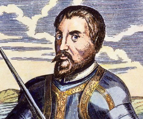
Described by a compatriot as “a man hard and dry of word,” de Soto was not an explorer in the sense of being someone who thrived on the discovery of new lands. He ventured into the unknown driven by one single-minded quest. He was after gold. Who and how many he killed in the search was of little concern.
De Soto gained his reputation (and some $10 million in gold and silver) in Peru where, with Francisco Pizarro González, he participated in the subjugation of the Inca people. Because of his wealth, he was appointed governor of Cuba and the adelantado—a title given to military leaders that allowed them to rule lands claimed for the king—of the region known as “La Florida” (basically the entire Southeast), which gave him royal authority to conquer the people and plunder their assumed riches for Spain. In May 1539, he landed an army of 600 conquistadores near present-day Tampa. They were heavily armored, and equipped with guns, artillery, some 200 horses, a herd of pigs (forerunners of today’s wild boar), and a legion of perros bravos, attack dogs trained to tear humans apart.
“De Soto cut a deadlier swath across the South than Katrina and Sherman’s March combined,” said Tony Horwitz, author of A Voyage Long and Strange—a book on early North American exploration—in a recent online interview.
“Brutal, even by conquistador standards, he enslaved, tortured, set dogs on, and often outrightly massacred Indians from Florida to Texas. But the greatest damage was inflicted by the introduction of European diseases to which Indians had no immunity. De Soto’s men described dozens of large city-states inhabited by thousands of people. Spaniards who visited the same territory just two decades after de Soto’s march found almost no trace remaining of these once-populous societies.”
Lured by tales of gold over the next ridge, de Soto didn’t slow down when he reached the Blue Ridge Mountains. Ironically, he not only missed finding the very riches he sought; New archaeological evidence shows that he likely traversed through one of the most gem- and mineral-rich areas of the Southeast.
“Very Given to Hunting and Killing Indians”
It takes a strong stomach to read the De Soto Chronicles, period accounts of his expedition written by four men, three of whom were members of his army. Rarely is a page turned without mention of torture, mayhem, or wholesale slaughter. As one chronicler wrote, de Soto was a man “very given to hunting and killing Indians.”
By the time de Soto reached what is now North Carolina, his tactics were well-honed. He would enter a village or town with great ceremony, generally greeting the tribal leaders with gifts and peaceful formalities. If it was determined that the tribe couldn’t offer any riches, there was a demand for food, as well as slaves to carry the vast equipment of the army. To prevent escape, the slaves were shackled together with chains around their necks. De Soto also “requisitioned” women to serve the army’s “lewdness and lust.” If the Indians refused these requests or attempted to flee, they were either thrown to the dogs or burned alive. The village was then sacked, the houses and crops torched before the army marched on.
As disturbing as the chronicles are with their tales of brutality, they also afford the first written description of the Southeast and provide an invaluable record of the native people who lived in the region during the 16th century.
“The Indians de Soto encountered were highly sophisticated,” explains Dr. David Moore, a professor of sociology and anthropology at Warren Wilson College, who has researched and written extensively on the early Spanish contact with the indigenous people of Western North Carolina. Moore has also overseen archaeological digs at what is widely considered the place where soldiers under Spanish explorer Juan Pardo established the short-lived Fort San Juan in 1566. This location near Morganton is now known as the Berry site—named after the family on whose farm it was discovered—and was also likely the village de Soto visited some 20 years earlier, which he called Xuala (pronounced “shualé”), and known by the natives as Joara.
“The Indians of Joara were in no way ignorant people,” says Moore, noting they were of the Mississippian mound-building period—a dominant Native American culture spanning from the Midwest through the Southeast—and perhaps ancestors of the Catawba Indian Nation. “One has to guess that, at the very least, they were evaluating the Spanish as carefully as the Spanish were eyeing them. The Spanish were after gold, a commodity that was of little importance to the Indians. As one of the leaders asked de Soto, ‘you value that?’” Copper, a sturdier metal than gold used to make tools and weapons, was of more value to the people of this area. “But since it was gold the Spanish wanted, the Indians quickly figured out the best way to appease de Soto was to say that, yes, there were tribes who did have gold, but they lived farther into the mountains,” says Moore. “Whether this was a planned strategy or not, we don’t know. Whatever the reasons, it worked. It sent de Soto out of their territory. Because the longer he stayed in a place, the greater the chance for the Indians to be hurt.”
Which Way Did He Go?
De Soto’s exact course through the Southeast has long been argued by scholars and historians. Yet in recent years, with information gleaned through modern methods and new archaeological discoveries, the route is becoming clearer.
Archaeological excavations at the Berry site have unearthed hundreds of thousands of Native American relics and more than 200 artifacts directly related to Spanish occupation. They have also brought to light a new theory on the path de Soto and his men took through North Carolina.
The route most favored by historians was charted by Dr. Charles Hudson, a professor emeritus at the University of Georgia and an anthropologist who spent some 25 years mapping the Spaniards’ expedition. Hudson and his team generally plotted de Soto’s path through North Carolina from Joara (Xuala) through the Swannanoa Valley to the French Broad and Pigeon rivers, ultimately reaching the high mountains near present-day Old Fort. He then traveled west to the place called Chiaha, near Erwin, Tennessee.
Given the Spanish artifacts found at the Berry site, however, Robin A. Beck, Jr., has now proposed a different route that took de Soto on a more northern track through the Toe River Valley. Beck’s route is rapidly gaining consensus among his peers.
An archeologist at the University of Oklahoma, Beck is a North Carolinian by birth and the Berry site is on land owned by his aunt and uncle, Pat and James Berry. As a boy, he cut his archaeological teeth here finding Indian artifacts in the fields. It was a find during his 20s, a 16th-century Spanish knife, that led to the larger discovery that this was not only the Indian town called Joara, but also the site of Fort San Juan and very likely the same place de Soto stopped.
In his paper, “Spanish Exploration of the Appalachian Summit Area,” Beck explains how he mapped the alternate route. “In addition to documentary sources,” he wrote, “I also used cartographic evidence to identify early roads and trails in the study area. Only under unusual circumstances did either [the de Soto or Pardo] expedition stray from well-marked trails. European settlers used many of these same trails through the 18th and early 19th centuries, when the first accurate maps of this region were produced.”
In fact, even today’s modern roadways are generally built over these early Indian trading paths. “These trade routes linked the entire Southeast and extended all the way west to the Mississippi and north into Canada,” says Moore. “Trade was the Indian’s economic vitality. While they didn’t use money, they had been trading valued commodities among different tribes for millennia. De Soto wasn’t hacking through virgin territory when he set out through the Southeast, but following definite, recognized Indian paths.”
Beck’s path makes sense. It also took
de Soto directly through North Carolina’s mining country, a land rich in emeralds, rubies, and even some gold. “It isn’t that strange that he missed these riches,” explains Moore. “These were things that had little value to the native people. It was not like Peru, where the Incas had been mining gems for centuries. Peru was easy picking for the conquistadores. De Soto was looking for a similar vast horde as he crossed the mountains. It was there, but it was all underground.”
Assessing the Damage
The goal of identifying de Soto’s route is to gain a clearer understanding of the effects the Spanish had on the native people who lived in North Carolina during that period. “Such refinements would allow archaeologists to more accurately pinpoint regional populations before and after initial European contact,” wrote Beck, adding that it would provide a means “to trace the extent to which early European contact disrupted native societies in this region.”
Indeed, even though de Soto passed quickly through the region, spending not quite a month, the result was still disastrous. “When Captain Juan Pardo arrived only 20 years later,” says Moore, “he immediately noticed a marked decrease in the Indian population compared with what de Soto had seen. This is the bigger and more important question for archaeologists and anthropologists. We know that both de Soto and Pardo’s expeditions changed completely the sociopolitical structure of the native people. Whether it was from the introduction of disease, through slavery, killing, or other circumstances is still not completely known. But by the time of colonization 200 years later, these tribes no longer existed. There had been a total population collapse of a group of people who had lived in the area for thousands of years.”
By the time de Soto crossed the fabled Mississippi in the summer of 1541, his army had dwindled to about 200 men who were ragged, close to starvation, surrounded, and in no condition to fight hostile Indians with their former brute strength. They had long since eaten their attack dogs, and their remaining horses were so weak they could barely walk. His men pleaded with him to halt the expedition and return to the Gulf of Mexico for safety. Yet de Soto kept on, determined to find his gold.
As he died of fever on a bank of the great river, one can only imagine that the men breathed a collective sigh of relief. He was not mourned. As one chronicler wrote, the “butcher-in-chief” was “no doubt now in the depths of Hell enjoying the wages of his wickedness.”
DETOURS AHEAD
One native archeaologist rethinks de Soto’s path through North Carolina’s Mountains
“All accounts agree that Xuala was located in the foothills,” wrote archaeologist Robin A. Beck, Jr., in his paper that attempts to replot the conquistadores’ path through Western North Carolina. De Soto Chronicles also notes that “they now had the mountains before them.”
They also state that when de Soto’s expedition left Xuala on May 25, 1540, they “crossed that day a very high mountain range, and they spent the night in a small forest.” To have traversed such tall mountains so quickly, Beck felt that de Soto’s actual route would have to differ significantly from the longer route through the Swannanoa Valley to Old Fort. The expedition could only travel about 15 miles each day.
Beck suggests, instead, that de Soto followed a trading path, which is now highway N.C. 181, running northwest from Morganton, passing just west of the Berry archeological site, then on to Table Rock and Hawksbill Mountain. Following this route, the distance from Xuala to high mountains is less than 15 miles. Beck proposes that the expedition then made camp near present-day Jonas Ridge.
After suffering “great cold” the following day, the chronicles state the expedition crossed a river in water up to their shins and “in these mountains we found the source of the great river… Espiritu Santo.” Beck thinks they were in the vicinity of Linville Falls, that the army had crossed the North Toe River near present-day Ingalls and were following a path that ran alongside the river, today’s U.S. 19E. Espiritu Santo was the Mississippi River and, indeed, the North Toe River does—by way of the Nolichucky, French Broad, Tennessee, and Ohio rivers—flow into the Mississippi.
Beck also believes de Soto’s route into Tennessee generally follows today’s U.S. 226, beginning near Webb, where the Toe and Cane rivers join to form the Nolichucky. Following the Nolichucky, “a large creek, which they crossed many times,” they then made camp near present-day Erwin, Tennessee.
Joara Then & Now
In December 1566, Captain Juan Pardo left his outpost near present-day Beaufort, South Carolina, and with 125 men and orders to claim the interior of the country for Spain, he traveled to the mountains. There, he established what is considered the oldest European settlement in North Carolina, also predating the English settlement at Roanoke by 18 years.
By January, Pardo and his men had arrived at the Indian settlement called Joara. Deciding to make the village his base of operations, he renamed the town Cuenca after his home in Spain and built a fortified encampment on the outskirts called Fort San Juan. Pardo and his men soon constructed five other forts in the region.
He returned the following September to find the fort in disarray and the native inhabitants incensed by his men’s continual demands for food, women, and with the mortal outbreaks of diseases the Spanish had brought with them.
In 1568, he learned that San Juan and the other installations had been burned to the ground by the natives. All but one of the 120 men at the forts had been killed.
During the 1960s and ‘70s, various archaeological surveys were conducted to determine possible locations of Joara. By the ‘80s, archaeologists had whittled down the number of possible sites, and limited excavations began. One spot, now known as the Berry site near Morganton had long yielded numerous native artifacts.
In 1986, an archaeological dig began recovering 16th-century Spanish artifacts, the evidence suggests that Berry was not only the location of Joara, but also the location of Fort San Juan. Perhaps the most dramatic evidence of this was the discovery of burned post footings.
Today, the site is protected and continued excavations are administered by Warren Wilson College and Western Piedmont Community College that conduct educational programs at the site each summer that are open to the public.
For more information on visiting the Berry site, visit
www.warren-wilson.edu/~arch/.